
Thank you for supporting this site ❤️
Make a donation
Make a donation
Dorena Lake topographic map
Click on the map to display elevation.
Thank you for supporting this site ❤️
Make a donation
Make a donation
About this map
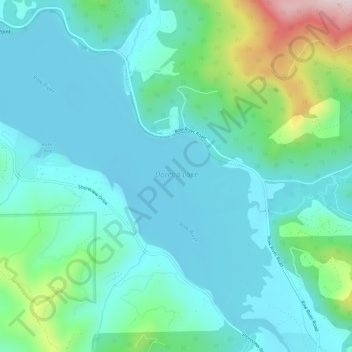
Name: Dorena Lake topographic map, elevation, terrain.
Location: Dorena Lake, Lane County, Oregon, United States (43.75021 -122.95545 43.79011 -122.89726)
Average elevation: 331 m
Minimum elevation: 235 m
Maximum elevation: 715 m
Thank you for supporting this site ❤️
Make a donation
Make a donation
Other topographic maps
Click on a map to view its topography, its elevation and its terrain.
Thank you for supporting this site ❤️
Make a donation
Make a donation
Thank you for supporting this site ❤️
Make a donation
Make a donation
Thank you for supporting this site ❤️
Make a donation
Make a donation
McKenzie River
United States > Oregon > Lane County > Rainbow
The McKenzie River drains a region of about 1,300 square miles (3,400 km2) and is one of the primary tributaries of the Willamette River. Elevations in the watershed range from 10,358 feet (3,157 m) at the summit of the South Sister to 375 feet (114 m) at the McKenzie's mouth on the Willamette River north of…
Average elevation: 431 m
Thank you for supporting this site ❤️
Make a donation
Make a donation
Thank you for supporting this site ❤️
Make a donation
Make a donation