
Thank you for supporting this site ❤️
Make a donation
Make a donation
Mehrhoog topographic map
Click on the map to display elevation.
Thank you for supporting this site ❤️
Make a donation
Make a donation
Mehrhoog
Der Ortsnamenteil Mehr sagt, dass der Ort in der Nähe eines Meers, eines früheren Rheinarms, liegt. Hoog bedeutet höher. Mehrhoog ist also der höher liegende Teil des alten Ortes Mehr.
Thank you for supporting this site ❤️
Make a donation
Make a donation
About this map
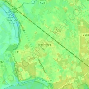
Name: Mehrhoog topographic map, elevation, terrain.
Average elevation: 21 m
Minimum elevation: 11 m
Maximum elevation: 27 m
Thank you for supporting this site ❤️
Make a donation
Make a donation
Other topographic maps
Click on a map to view its topography, its elevation and its terrain.