
Thank you for supporting this site ❤️
Make a donation
Make a donation
Berechurch topographic map
Click on the map to display elevation.
Thank you for supporting this site ❤️
Make a donation
Make a donation
About this map
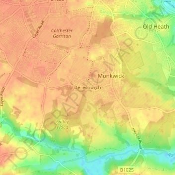
Name: Berechurch topographic map, elevation, terrain.
Location: Berechurch, Colchester, Essex, England, CO2 8WT, United Kingdom (51.84040 0.87905 51.88040 0.91905)
Average elevation: 28 m
Minimum elevation: 1 m
Maximum elevation: 41 m
Thank you for supporting this site ❤️
Make a donation
Make a donation
Other topographic maps
Click on a map to view its topography, its elevation and its terrain.
Thank you for supporting this site ❤️
Make a donation
Make a donation
Wivenhoe Woods
United Kingdom > England > Essex > Colchester > Wivenhoe > Rowhedge
Average elevation: 18 m
Thank you for supporting this site ❤️
Make a donation
Make a donation
Great Horkesley
United Kingdom > England > Essex > Colchester > Great Horkesley
Average elevation: 45 m
Thank you for supporting this site ❤️
Make a donation
Make a donation
Thank you for supporting this site ❤️
Make a donation
Make a donation
Thank you for supporting this site ❤️
Make a donation
Make a donation