
Thank you for supporting this site ❤️
Make a donation
Make a donation
Kaduna North topographic map
Click on the map to display elevation.
Thank you for supporting this site ❤️
Make a donation
Make a donation
Kaduna North
The topographical relief is relatively flat, having an elevation of between 600 and 650 metres in large areas of the local government. It is over 650 metres above mean sea level (a.m.s.l.) in some places, and below 500 metres in places that slope downward towards the river.
Thank you for supporting this site ❤️
Make a donation
Make a donation
About this map
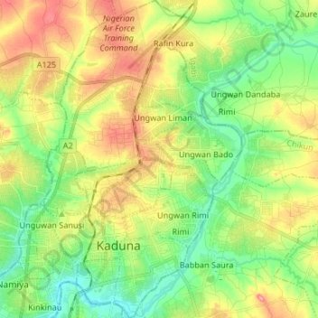
Name: Kaduna North topographic map, elevation, terrain.
Location: Kaduna North, Kaduna State, Nigeria (10.48850 7.41146 10.61861 7.48740)
Average elevation: 609 m
Minimum elevation: 569 m
Maximum elevation: 665 m
Thank you for supporting this site ❤️
Make a donation
Make a donation
Other topographic maps
Click on a map to view its topography, its elevation and its terrain.
Kaduna South
Nigeria > Kaduna State > Kaduna South > Kakuri Hausa > Kaduna South
Average elevation: 599 m
Thank you for supporting this site ❤️
Make a donation
Make a donation