Geolocate

Spanish Fort topographic map

Interactive map

Click on the map to display elevation.

About this map

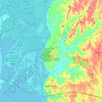
Name: Spanish Fort topographic map, elevation, terrain.

Location: Spanish Fort, Baldwin County, Alabama, 36577, United States (30.65533 -88.00585 30.83526 -87.76869)

Average elevation: 21 m

Minimum elevation: -2 m

Maximum elevation: 81 m

Other topographic maps

Click on a map to view its topography, its elevation and its terrain.

Daphne

United States > Alabama > Baldwin County

The topography of Daphne is quite consistent from a gently sloping sea level on the west to low rolling hills further east. Generally, the entire city lies no more than 150 feet above sea level. The land along the Daphne bay coast, like other land throughout the county, is rich with sandy-loam type soils.

Average elevation: 25 m

Park City

United States > Alabama > Baldwin County > Daphne

Average elevation: 17 m

Orange Beach

United States > Alabama > Baldwin County

Average elevation: 4 m

Jackson Oak

United States > Alabama > Baldwin County > Daphne

Average elevation: 20 m

Fairhope

United States > Alabama > Baldwin County

According to the United States Census Bureau, the city has a total area of 12.0 square miles (31.1 km2), of which 0.019 square mile (0.05 km2), or 0.16%, is water. Its elevation ranges from sea level at the bay to 122 feet (37 m) in the city center.

Average elevation: 17 m

Gulf Shores

United States > Alabama > Baldwin County

Average elevation: 5 m