
Make a donation
Amozoc topographic map
Click on the map to display elevation.
Make a donation
About this map
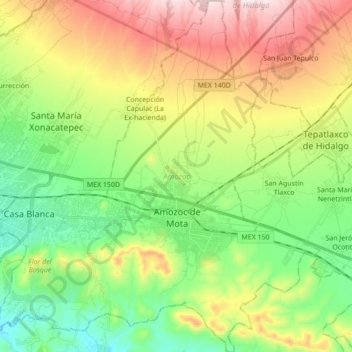
Name: Amozoc topographic map, elevation, terrain.
Location: Amozoc, Puebla, Mexico (18.98203 -98.13710 19.14579 -97.97376)
Average elevation: 2,397 m
Minimum elevation: 2,162 m
Maximum elevation: 2,774 m
Make a donation
Other topographic maps
Click on a map to view its topography, its elevation and its terrain.
Atlixco
The city of Atlixco is in the west of the state of Puebla at an elevation of 1,881 meters above sea level, 25 km from the state capital of Puebla. The main economic activities of the city are agriculture and basic commerce. It lies at the foot of the Cerro de San Miguel mountain, which is the main geographical…
Average elevation: 1,873 m
Make a donation
Make a donation
Sierra Negra
Mexico > Puebla > Chalchicomula de Sesma
Sierra Negra is located within the Pico de Orizaba National Park. The mountain is the site for two of the world's premier astronomical instruments, the Large Millimeter Telescope and the High Altitude Water Cherenkov Observatory. Therefore, the access to the mountain is restricted and has to be applied for at…
Average elevation: 4,099 m
Make a donation
Make a donation