
Thank you for supporting this site ❤️
Make a donation
Make a donation
Schöneshof topographic map
Click on the map to display elevation.
Thank you for supporting this site ❤️
Make a donation
Make a donation
About this map
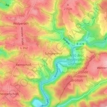
Name: Schöneshof topographic map, elevation, terrain.
Average elevation: 171 m
Minimum elevation: 85 m
Maximum elevation: 230 m
Thank you for supporting this site ❤️
Make a donation
Make a donation
Other topographic maps
Click on a map to view its topography, its elevation and its terrain.
Eischeid
Deutschland > Nordrhein-Westfalen > Rhein-Sieg-Kreis > Neunkirchen-Seelscheid
Average elevation: 187 m
Wolperath
Deutschland > Nordrhein-Westfalen > Rhein-Sieg-Kreis > Neunkirchen-Seelscheid
Average elevation: 175 m
53819
Deutschland > Nordrhein-Westfalen > Rhein-Sieg-Kreis > Neunkirchen-Seelscheid > Niederwennerscheid
Average elevation: 190 m
Seelscheid
Deutschland > Nordrhein-Westfalen > Rhein-Sieg-Kreis > Neunkirchen-Seelscheid > Hausen
Average elevation: 191 m
Thank you for supporting this site ❤️
Make a donation
Make a donation