
Signal Hill National Historic Site topographic map
Interactive map
Click on the map to display elevation.
About this map
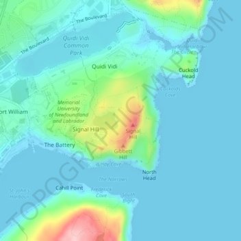
Name: Signal Hill National Historic Site topographic map, elevation, terrain.
Average elevation: 29 m
Minimum elevation: -1 m
Maximum elevation: 175 m
Other topographic maps
Click on a map to view its topography, its elevation and its terrain.
St. John's
Canada > Terre-Neuve et Labrador > St. John's
St. John's, Terre-Neuve, Terre-Neuve et Labrador, Canada
Average elevation: 76 m
The Klondyke
Canada > Terre-Neuve et Labrador > St. John's
The Klondyke, St. John's, Terre-Neuve et Labrador, Canada
Average elevation: 156 m