
Thank you for supporting this site ❤️
Make a donation
Make a donation
Crest Estates topographic map
Click on the map to display elevation.
Thank you for supporting this site ❤️
Make a donation
Make a donation
About this map
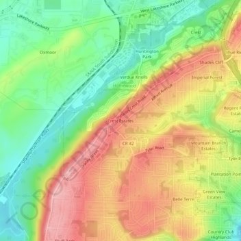
Name: Crest Estates topographic map, elevation, terrain.
Average elevation: 249 m
Minimum elevation: 166 m
Maximum elevation: 340 m
Thank you for supporting this site ❤️
Make a donation
Make a donation
Other topographic maps
Click on a map to view its topography, its elevation and its terrain.
Loch Haven Park
United States > Alabama > Jefferson County > Hoover > Cedar Crest
Average elevation: 159 m