
Thank you for supporting this site ❤️
Make a donation
Make a donation
Prest topographic map
Click on the map to display elevation.
Thank you for supporting this site ❤️
Make a donation
Make a donation
About this map
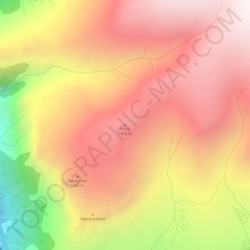
Name: Prest topographic map, elevation, terrain.
Location: Prest, Aurland, Vestland, 5745, Norway (60.93615 7.24094 60.93625 7.24104)
Average elevation: 1,218 m
Minimum elevation: 454 m
Maximum elevation: 1,685 m
Thank you for supporting this site ❤️
Make a donation
Make a donation
Other topographic maps
Click on a map to view its topography, its elevation and its terrain.
Thank you for supporting this site ❤️
Make a donation
Make a donation
Thank you for supporting this site ❤️
Make a donation
Make a donation