
Thank you for supporting this site ❤️
Make a donation
Make a donation
Monschau topographic map
Click on the map to display elevation.
Thank you for supporting this site ❤️
Make a donation
Make a donation
Monschau
At two meetings in the spring meet canoeists for about 50 years in Monschau international events, and a whitewater races. Nationally known is the Monschau Marathon more than 760 meters of altitude, which takes place in August.
Thank you for supporting this site ❤️
Make a donation
Make a donation
About this map
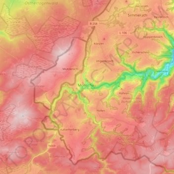
Name: Monschau topographic map, elevation, terrain.
Average elevation: 551 m
Minimum elevation: 307 m
Maximum elevation: 670 m
Thank you for supporting this site ❤️
Make a donation
Make a donation
Other topographic maps
Click on a map to view its topography, its elevation and its terrain.