
Thank you for supporting this site ❤️
Make a donation
Make a donation
Frankfurt (Oder) topographic map
Click on the map to display elevation.
Thank you for supporting this site ❤️
Make a donation
Make a donation
About this map
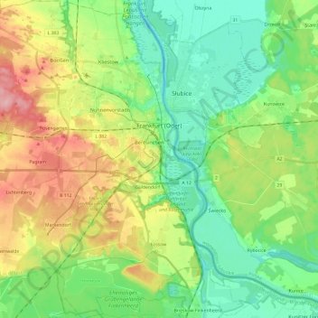
Name: Frankfurt (Oder) topographic map, elevation, terrain.
Location: Frankfurt (Oder), Brandenburg, Germany (52.25287 14.39483 52.39807 14.60136)
Average elevation: 54 m
Minimum elevation: 8 m
Maximum elevation: 138 m
Thank you for supporting this site ❤️
Make a donation
Make a donation
Other topographic maps
Click on a map to view its topography, its elevation and its terrain.
Battle of the Seelow Heights
Germany > Brandenburg > Märkisch-Oderland > Seelow
Average elevation: 22 m
Thank you for supporting this site ❤️
Make a donation
Make a donation