
Thank you for supporting this site ❤️
Make a donation
Make a donation
Banshkhali topographic map
Click on the map to display elevation.
Thank you for supporting this site ❤️
Make a donation
Make a donation
About this map
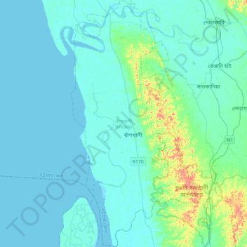
Name: Banshkhali topographic map, elevation, terrain.
Average elevation: 11 m
Minimum elevation: -2 m
Maximum elevation: 96 m
Thank you for supporting this site ❤️
Make a donation
Make a donation
Other topographic maps
Click on a map to view its topography, its elevation and its terrain.
Rajeshpur Eco-Park
Bangladesh > Chattogram Division > Cumilla Adarsha Sadar Upazila
Average elevation: 15 m