
Thank you for supporting this site ❤️
Make a donation
Make a donation
Schreckhorn topographic map
Click on the map to display elevation.
Thank you for supporting this site ❤️
Make a donation
Make a donation
Schreckhorn
Das Schreckhorn ist mit einer Höhe von 4078 m ü. M. der nördlichste Viertausender Europas. Es befindet sich in den Berner Alpen im Kanton Bern in der Schweiz. Geologisch gehört das Schreckhorn zum Aarmassiv und besteht aus Erstfeldergneis.
Thank you for supporting this site ❤️
Make a donation
Make a donation
About this map
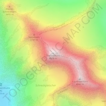
Name: Schreckhorn topographic map, elevation, terrain.
Average elevation: 3,271 m
Minimum elevation: 2,447 m
Maximum elevation: 4,069 m
Thank you for supporting this site ❤️
Make a donation
Make a donation