
Make a donation
Port Angeles topographic map
Click on the map to display elevation.
Make a donation
Port Angeles
Port Angeles is characterized by a diverse and dramatic topography that reflects its unique geographic position on the Olympic Peninsula. Situated at approximately 72 feet above sea level, the city rises from the shores of the Strait of Juan de Fuca and is bordered by the Olympic Mountains to the south, which soar to elevations exceeding 7,000 feet. This mountainous backdrop is notable for its steep slopes and deep valleys, shaped by glacial activity and erosion. The surrounding landscape features a mixture of rugged terrain and lush forests, with numerous rivers and streams that traverse the area, enhancing its scenic beauty and providing habitats for local wildlife. Additionally, the coastline is marked by rocky shorelines and sandy beaches, creating a rich environment for both recreation and biodiversity.
Make a donation
About this map
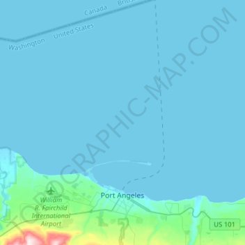
Name: Port Angeles topographic map, elevation, terrain.
Average elevation: 27 m
Minimum elevation: -6 m
Maximum elevation: 501 m
Make a donation
Other topographic maps
Click on a map to view its topography, its elevation and its terrain.
Make a donation
Make a donation