
Thank you for supporting this site ❤️
Make a donation
Make a donation
Freeland topographic map
Click on the map to display elevation.
Thank you for supporting this site ❤️
Make a donation
Make a donation
About this map
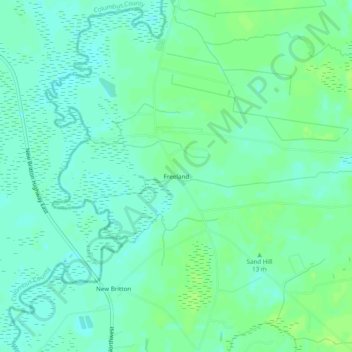
Name: Freeland topographic map, elevation, terrain.
Location: Freeland, Brunswick County, North Carolina, United States (34.08711 -78.55723 34.12711 -78.51723)
Average elevation: 12 m
Minimum elevation: 6 m
Maximum elevation: 18 m
Thank you for supporting this site ❤️
Make a donation
Make a donation
Other topographic maps
Click on a map to view its topography, its elevation and its terrain.
North Carolina Coastal Land Trust: Orton Plantation Holdings, LLC
United States > North Carolina > Brunswick County
Average elevation: 8 m
Thank you for supporting this site ❤️
Make a donation
Make a donation
Boiling Spring Lake
United States > North Carolina > Brunswick County > Boiling Spring Lakes
Average elevation: 14 m