
Make a donation
Kibungan topographic map
Click on the map to display elevation.
Make a donation
Kibungan
The municipality is within a cool highland mountainous zone with elevations at more than 2,500 metres (8,200 ft) above sea level. During its coolest months of December to January, Barangay Madaymen experiences chilling temperature of 0 °C (32 °F), causing the famous Frost of Madaymen.
Make a donation
About this map
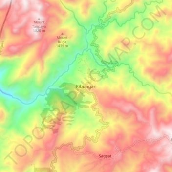
Name: Kibungan topographic map, elevation, terrain.
Average elevation: 1,249 m
Minimum elevation: 562 m
Maximum elevation: 1,844 m
Make a donation
Other topographic maps
Click on a map to view its topography, its elevation and its terrain.
Ambuklao Dam
Philippines > Benguet > Ambuclao > Ambangol
SNAP-Benguet began a massive rehabilitation project that restored Ambuklao to operating status and increased its capacity from 75 MW to 105 MW. The project required the construction of a new intake, headrace and penstock, elevation of tailrace tunnel outlet, de-silting of tailrace tunnel and replacement of…
Average elevation: 808 m
Waiting shed at the OPAg building, Wangal
Philippines > Benguet > La Trinidad > Upper Wangal
Average elevation: 1,352 m