
Make a donation
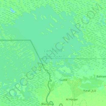
Lake Chad topographic map
Click on the map to display elevation.
Make a donation
Lake Chad
Lake Chad is divided into north and south parts by a shallow sill called the Great Barrier, with the bottom of the northern basin at an altitude of 275.3 m (903 ft) and the bottom of the southern basin at 278.2 m (913 ft). When the water level in the south exceeds 279 m (915 ft) above sea level, it will flow into the north. In the south, there is continuous open water at the mouth of the Chari River, and the western part of the water is covered by reed swamps, and the sand dunes that are not completely submerged in the eastern waters form an archipelago. The average depth of the southern lake basin is between .5 and 2 m (1 ft 8 in and 6 ft 7 in), that of the northern lake basin is between 0 and 1.8 m (5 ft 11 in), and that of the eastern archipelago is between 0 and 2 m (6 ft 7 in).
Make a donation
About this map
Name: Lake Chad topographic map, elevation, terrain.
Location: Lake Chad, Hadjer-Lamis, Chad (12.78275 14.25009 13.25896 14.77822)
Average elevation: 282 m
Minimum elevation: 274 m
Maximum elevation: 335 m
Make a donation
Other topographic maps
Click on a map to view its topography, its elevation and its terrain.