
Ripple topographic map
Click on the map to display elevation.
About this map
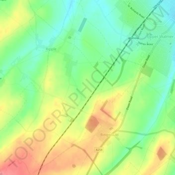
Name: Ripple topographic map, elevation, terrain.
Location: Ripple, Dover, Kent, England, United Kingdom (51.17644 1.33942 51.20974 1.38622)
Average elevation: 43 m
Minimum elevation: 6 m
Maximum elevation: 89 m
Other topographic maps
Click on a map to view its topography, its elevation and its terrain.
St Margaret's Bay
United Kingdom > England > Kent > Dover > St. Margaret's at Cliffe
Average elevation: 38 m
White Cliffs of Dover
United Kingdom > England > Kent > Dover > St. Margaret's at Cliffe
Average elevation: 49 m