
Ule topographic map
Interactive map
Click on the map to display elevation.
About this map
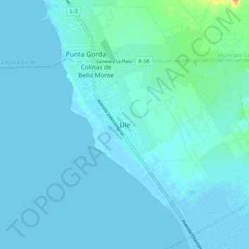
Name: Ule topographic map, elevation, terrain.
Average elevation: 5 m
Minimum elevation: -5 m
Maximum elevation: 54 m
Other topographic maps
Click on a map to view its topography, its elevation and its terrain.
Costa Oriental del Lago
Venezuela > Estado Zulia > Municipio Simón Bolívar > Tía Juana
Costa Oriental del Lago, Tía Juana, Parroquia Manuel Manrique, Municipio Simón Bolívar, Estado Zulia, 4017, Venezuela
Average elevation: 162 m