
Make a donation
Joggins topographic map
Click on the map to display elevation.
Make a donation
About this map
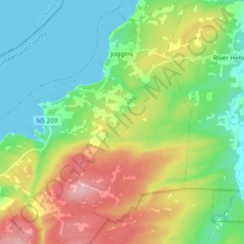
Name: Joggins topographic map, elevation, terrain.
Average elevation: 55 m
Minimum elevation: 0 m
Maximum elevation: 156 m
Make a donation
Other topographic maps
Click on a map to view its topography, its elevation and its terrain.
Chignecto Isthmus
Canada > Nova Scotia > Municipality of the County of Cumberland > Fort Lawrence
Average elevation: 14 m
River Philip Centre
Canada > Nova Scotia > Municipality of the County of Cumberland
Average elevation: 85 m
Mullins Point
Canada > Nova Scotia > Municipality of the County of Cumberland > North Wallace
Average elevation: 2 m
Blue Sea Corner
Canada > Nova Scotia > Municipality of the County of Cumberland > Malagash Point
Average elevation: 11 m
Make a donation
Westchester Valley
Canada > Nova Scotia > Municipality of the County of Cumberland
Average elevation: 194 m
Glasgow Mountain
Canada > Nova Scotia > Municipality of the County of Cumberland > Diligent River
Average elevation: 143 m
Two Rivers
Canada > Nova Scotia > Municipality of the County of Cumberland > Joggins
Average elevation: 52 m
Canaan Mountains
Canada > Nova Scotia > Municipality of the County of Cumberland > New Canaan
Average elevation: 97 m
Make a donation
Cameron Beach
Canada > Nova Scotia > Municipality of the County of Cumberland > Port Howe
Average elevation: 2 m
Pugwash Point
Canada > Nova Scotia > Municipality of the County of Cumberland > Pugwash
Average elevation: 4 m
Upper Gulf Shore
Canada > Nova Scotia > Municipality of the County of Cumberland > Gulf Shore
Average elevation: 12 m
Mitchells Beach
Canada > Nova Scotia > Municipality of the County of Cumberland > West Pugwash
Average elevation: 7 m
Make a donation
Cape Chignecto
Canada > Nova Scotia > Municipality of the County of Cumberland > Cape Chignecto Provincial Park
Average elevation: 20 m
Cape Chignecto
Canada > Nova Scotia > Municipality of the County of Cumberland > Cape Chignecto Provincial Park
Average elevation: 20 m