
Make a donation
Ripač topographic map
Click on the map to display elevation.
Make a donation
About this map
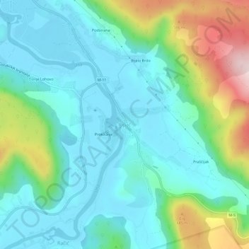
Name: Ripač topographic map, elevation, terrain.
Average elevation: 316 m
Minimum elevation: 223 m
Maximum elevation: 600 m
Make a donation
Other topographic maps
Click on a map to view its topography, its elevation and its terrain.
Bihać
Bosnia and Herzegovina > Federation of Bosnia and Herzegovina > City of Bihać
Average elevation: 368 m
Bihać
Bosnia and Herzegovina > Federation of Bosnia and Herzegovina > City of Bihać
Average elevation: 368 m
Una
Bosnia and Herzegovina > Federation of Bosnia and Herzegovina > City of Bihać > Bihać
Average elevation: 255 m
Una
Bosnia and Herzegovina > Federation of Bosnia and Herzegovina > City of Bihać > Bihać
Average elevation: 255 m
Make a donation
Bihać
Bosnia and Herzegovina > Federation of Bosnia and Herzegovina > City of Bihać
Average elevation: 368 m
Bihać
Bosnia and Herzegovina > Federation of Bosnia and Herzegovina > City of Bihać
Average elevation: 368 m
Bihać
Bosnia and Herzegovina > Federation of Bosnia and Herzegovina > City of Bihać
Average elevation: 368 m
Bihać
Bosnia and Herzegovina > Federation of Bosnia and Herzegovina > City of Bihać
Average elevation: 368 m
Make a donation