
Thank you for supporting this site ❤️
Make a donation
Make a donation
Venice topographic map
Click on the map to display elevation.
Thank you for supporting this site ❤️
Make a donation
Make a donation
About this map
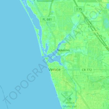
Name: Venice topographic map, elevation, terrain.
Location: Venice, Sarasota County, Florida, 34285, United States (27.06068 -82.46783 27.16894 -82.35958)
Average elevation: 4 m
Minimum elevation: -2 m
Maximum elevation: 12 m
Thank you for supporting this site ❤️
Make a donation
Make a donation
Other topographic maps
Click on a map to view its topography, its elevation and its terrain.