
Thank you for supporting this site ❤️
Make a donation
Make a donation
Jefferson topographic map
Click on the map to display elevation.
Thank you for supporting this site ❤️
Make a donation
Make a donation
About this map
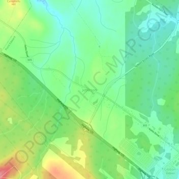
Name: Jefferson topographic map, elevation, terrain.
Average elevation: 34 m
Minimum elevation: 0 m
Maximum elevation: 97 m
Thank you for supporting this site ❤️
Make a donation
Make a donation
Other topographic maps
Click on a map to view its topography, its elevation and its terrain.
Margaret Boone Memorial Park
Canada > Nova Scotia > Cape Breton Regional Municipality > Dominion
Average elevation: 13 m
Cary Rocks Cove
Canada > Nova Scotia > Cape Breton Regional Municipality > Main-à-Dieu
Average elevation: 3 m
Thank you for supporting this site ❤️
Make a donation
Make a donation
Thank you for supporting this site ❤️
Make a donation
Make a donation
Glace Bay
Canada > Nova Scotia > Cape Breton Regional Municipality > Glace Bay
Average elevation: 15 m