
Semmes topographic map
Click on the map to display elevation.
Semmes
Semmes is located in west-central Mobile County at 30°46′40″N 88°15′32″W / 30.77778°N 88.25889°W / 30.77778; -88.25889. The elevation is 244 feet (74 m) above sea level. It is 11 miles (18 km) west of Prichard and 15 miles (24 km) northwest of downtown Mobile. U.S. Route 98 (Moffett Road) is the main highway through Semmes, leading southeast into Mobile and northwest 77 miles (124 km) to Hattiesburg, Mississippi.
About this map
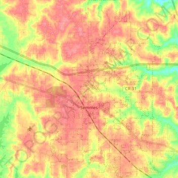
Name: Semmes topographic map, elevation, terrain.
Location: Semmes, Mobile County, Alabama, 36663, United States (30.73045 -88.28925 30.85166 -88.20242)
Average elevation: 59 m
Minimum elevation: 16 m
Maximum elevation: 85 m
Other topographic maps
Click on a map to view its topography, its elevation and its terrain.
Coden
United States > Alabama > Mobile County
Coden is located at 30°22′59″N 88°14′18″W / 30.38306°N 88.23833°W / 30.38306; -88.23833 and has an elevation of 7 feet (2 m).
Average elevation: 3 m
Saint Elmo
United States > Alabama > Mobile County
St. Elmo is located at 30°30′13″N 088°15′15″W / 30.50361°N 88.25417°W / 30.50361; -88.25417. The elevation is 135 feet (41 m). Most of the town lies along U.S. Highway 90.
Average elevation: 41 m
Coden
United States > Alabama > Mobile County
Coden is located at 30°22′59″N 88°14′18″W / 30.38306°N 88.23833°W / 30.38306; -88.23833 and has an elevation of 7 feet (2 m).
Average elevation: 3 m
Coden
United States > Alabama > Mobile County
Coden is located at 30°22′59″N 88°14′18″W / 30.38306°N 88.23833°W / 30.38306; -88.23833 and has an elevation of 7 feet (2 m).
Average elevation: 3 m
Semmes
United States > Alabama > Mobile County > Semmes
Semmes is located at 30.778N, -88.259W. Elevation is 256 feet. The Semmes area is bounded to the North by the Citronelle area, bounded to the East by the cities of Saraland and Prichard, bounded to the South by the city of Mobile, and finally bounded to the West by Big Creek Lake.
Average elevation: 68 m