
Thank you for supporting this site ❤️
Make a donation
Make a donation
Aguas Calientes topographic map
Click on the map to display elevation.
Thank you for supporting this site ❤️
Make a donation
Make a donation
About this map
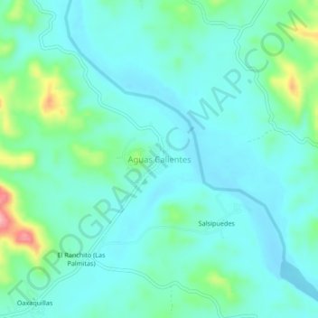
Name: Aguas Calientes topographic map, elevation, terrain.
Location: Aguas Calientes, Acapulco de Juárez, Guerrero, Mexico (16.82194 -99.66083 16.86194 -99.62083)
Average elevation: 42 m
Minimum elevation: 14 m
Maximum elevation: 152 m
Thank you for supporting this site ❤️
Make a donation
Make a donation
Other topographic maps
Click on a map to view its topography, its elevation and its terrain.
Centro Internacional Acapulco
Mexico > Guerrero > Acapulco de Juárez > Acapulco
Average elevation: 68 m