
Make a donation
Ansonia topographic map
Click on the map to display elevation.
Make a donation
About this map
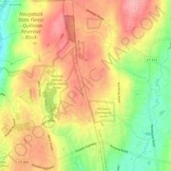
Name: Ansonia topographic map, elevation, terrain.
Average elevation: 111 m
Minimum elevation: 43 m
Maximum elevation: 162 m
Make a donation
Other topographic maps
Click on a map to view its topography, its elevation and its terrain.
Derby
United States > Connecticut > Naugatuck Valley Planning Region
According to the United States Census Bureau, the town has a total area of 5.4 square miles (8.7 km2), of which, 5.0 square miles (13 km2) is land and 0.4 square miles (1.0 km2) (7.41%) is water. The city is home to the 417 acres (0.652 sq mi) Osbornedale State Park. Derby is divided into two main sections by…
Average elevation: 78 m
Make a donation
Huntington
United States > Connecticut > Naugatuck Valley Planning Region > Shelton
Average elevation: 111 m
Naugatuck State Forest
United States > Connecticut > Naugatuck Valley Planning Region > Beacon Falls
Average elevation: 137 m
Minortown
United States > Connecticut > Naugatuck Valley Planning Region > Woodbury
Average elevation: 169 m
Make a donation
Wolcott
United States > Connecticut > Naugatuck Valley Planning Region
The highest point in New Haven County is found in Wolcott atop Lindsley Hill, which has an elevation of approximately 1,046 feet above sea level.
Average elevation: 209 m
Watertown
United States > Connecticut > Naugatuck Valley Planning Region
Watertown is in southeastern Litchfield County and is bordered to the southeast by the city of Waterbury in New Haven County. Other bordering towns are Middlebury to the south, Woodbury and Bethlehem to the west, Morris to the northwest, and Thomaston to the east. It is in the Eastern Standard time zone. The…
Average elevation: 199 m
Make a donation
Prospect
United States > Connecticut > Naugatuck Valley Planning Region
According to the Köppen classification, Prospect is Dfb, or a humid continental climate. The town has warm and humid summers with cold winters. Precipitation is spread throughout the year, with thunderstorms frequent during the summer months, and heavy snowfalls during the winter months. Due to Prospect's…
Average elevation: 193 m
Oakville
United States > Connecticut > Naugatuck Valley Planning Region > Watertown > Oakville
Average elevation: 172 m
White Hills
United States > Connecticut > Naugatuck Valley Planning Region > Shelton
Average elevation: 124 m
Make a donation
Make a donation
Make a donation
Make a donation
Prospect
United States > Connecticut > Naugatuck Valley Planning Region
According to the Köppen classification, Prospect is Dfb, or a humid continental climate. The town has warm and humid summers with cold winters. Precipitation is spread throughout the year, with thunderstorms frequent during the summer months, and heavy snowfalls during the winter months. Due to Prospect's…
Average elevation: 193 m
Wolcott
United States > Connecticut > Naugatuck Valley Planning Region
The highest point in New Haven County is found in Wolcott atop Lindsley Hill, which has an elevation of approximately 1,046 feet above sea level.
Average elevation: 209 m
Fox Hollow
United States > Connecticut > Naugatuck Valley Planning Region > Cheshire
Average elevation: 64 m
Make a donation
Westview Heights
United States > Connecticut > Naugatuck Valley Planning Region > Middlebury
Average elevation: 159 m
Union City
United States > Connecticut > Naugatuck Valley Planning Region > Naugatuck
Average elevation: 124 m
Warsaw Park
United States > Connecticut > Naugatuck Valley Planning Region > Ansonia
Average elevation: 107 m
Make a donation
Bunker Hill
United States > Connecticut > Naugatuck Valley Planning Region > Waterbury
Average elevation: 140 m
Cedar Land
United States > Connecticut > Naugatuck Valley Planning Region > Southbury
Average elevation: 103 m
Town Plot Hill
United States > Connecticut > Naugatuck Valley Planning Region > Waterbury
Average elevation: 127 m
Make a donation
Millville
United States > Connecticut > Naugatuck Valley Planning Region > Naugatuck
Average elevation: 132 m
Bunker Hill
United States > Connecticut > Naugatuck Valley Planning Region > Waterbury
Average elevation: 140 m
Bunker Hill
United States > Connecticut > Naugatuck Valley Planning Region > Waterbury
Average elevation: 140 m
Make a donation
Traditions
United States > Connecticut > Naugatuck Valley Planning Region > Southbury > South Britain
Average elevation: 112 m
Minortown
United States > Connecticut > Naugatuck Valley Planning Region > Woodbury
Average elevation: 169 m
Make a donation
Derby
United States > Connecticut > Naugatuck Valley Planning Region
According to the United States Census Bureau, the town has a total area of 5.4 square miles (8.7 km2), of which, 5.0 square miles (13 km2) is land and 0.4 square miles (1.0 km2) (7.41%) is water. The city is home to the 417 acres (0.652 sq mi) Osbornedale State Park. Derby is divided into two main sections by…
Average elevation: 78 m
Gulls Hollow
United States > Connecticut > Naugatuck Valley Planning Region > Bethlehem
Average elevation: 243 m
Allentown
United States > Connecticut > Naugatuck Valley Planning Region > Plymouth
Average elevation: 244 m
Wolcott
United States > Connecticut > Naugatuck Valley Planning Region
The highest point in New Haven County is found in Wolcott atop Lindsley Hill, which has an elevation of approximately 1,046 feet above sea level.
Average elevation: 209 m
Make a donation
Make a donation