
Thank you for supporting this site ❤️
Make a donation
Make a donation
Benz topographic map
Click on the map to display elevation.
Thank you for supporting this site ❤️
Make a donation
Make a donation
About this map
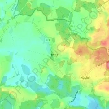
Name: Benz topographic map, elevation, terrain.
Location: Benz, Malente, Ostholstein, Schleswig-Holstein, Deutschland (54.19007 10.61177 54.23007 10.65177)
Average elevation: 57 m
Minimum elevation: 27 m
Maximum elevation: 116 m
Thank you for supporting this site ❤️
Make a donation
Make a donation
Other topographic maps
Click on a map to view its topography, its elevation and its terrain.
Kellersee
Deutschland > Schleswig-Holstein > Ostholstein > Malente > Krummsee
Der ungleichmäßig geformte See hat bei einer Länge von ungefähr 3,2 km und einer Breite von 3,7 km eine Wasseroberfläche von 555 ha, eine Tiefe von bis zu 25,8 m, wobei der Durchschnitt bei 11,7 m liegt, und eine Höhe über dem Meeresspiegel von etwa 24 m.[1]
Average elevation: 33 m