
Thank you for supporting this site ❤️
Make a donation
Make a donation
Blue River topographic map
Click on the map to display elevation.
Thank you for supporting this site ❤️
Make a donation
Make a donation
About this map
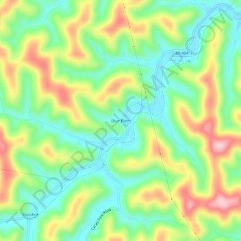
Name: Blue River topographic map, elevation, terrain.
Location: Blue River, Floyd County, Kentucky, 41607, United States (37.59926 -82.86377 37.63926 -82.82377)
Average elevation: 277 m
Minimum elevation: 189 m
Maximum elevation: 414 m
Thank you for supporting this site ❤️
Make a donation
Make a donation
Other topographic maps
Click on a map to view its topography, its elevation and its terrain.