
Make a donation
Walnut Grove topographic map
Click on the map to display elevation.
Make a donation
Walnut Grove
Walnut Grove's location has made it the site of a rare collection of very tall radio and television transmission towers. The first major tower here was the KXTV/KOVR/KCRA Tower built in 1962, which dominated the skyline for over twenty years with its 1,548 foot height. In 1985 the old tower was joined by taller structures. The guyed KXTV/KOVR Tower is, with a height of 2,048 feet, one of the tallest constructions in the world. Two other guyed towers of similar height are the 1,996 foot high Channel 40 Tower, KTXL, and the 2,000 foot high Hearst-Argyle Tower. Towers sited here at the natural corner of the California Central Valley have line of sight coverage of flat valley floor for over 60 miles(100 kilometers) to the north and to the south-southeast, and quite good coverage into the Sierra foothills and mountains across the valley to the northeast and east. However, these towers and their guy-wires are a significant hazard to aircraft, which can otherwise freely cross most of the Central Valley at 656 feet of altitude.
Make a donation
About this map
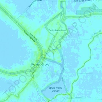
Name: Walnut Grove topographic map, elevation, terrain.
Average elevation: 1 m
Minimum elevation: -3 m
Maximum elevation: 9 m
Make a donation
Other topographic maps
Click on a map to view its topography, its elevation and its terrain.
American River
United States > California > Sacramento County > Rancho Cordova
The North Fork is the longest tributary of the American River, at 88 miles (142 km). It begins at an elevation of about 7,900 feet (2,400 m) near Lake Tahoe in Placer County at Mountain Meadow Lake, just northeast of Granite Chief and immediately due west of Palisades Tahoe (formerly Squaw Valley) Ski Resort.…
Average elevation: 44 m
Folsom
United States > California > Sacramento County
Carpenter Hill in Folsom has the highest elevation in Sacramento County.
Average elevation: 90 m
Make a donation
Folsom
United States > California > Sacramento County
Carpenter Hill in Folsom has the highest elevation in Sacramento County.
Average elevation: 90 m
Make a donation
William B. Pond Recreation Area
United States > California > Sacramento County
Average elevation: 21 m
Make a donation
Make a donation
Make a donation
Folsom
United States > California > Sacramento County
Carpenter Hill in Folsom has the highest elevation in Sacramento County, at 831 feet (253 meters).
Average elevation: 90 m
Make a donation
Rancho Cordova
United States > California > Sacramento County
In the Gold Rush era of mid-19th-century California, placer mining took place around Rancho Cordova, and some traces of it can still be found. The elevation of the generally level terrain is approximately 118 feet (36 m) above mean sea level. Lone Star Gravel Company and other companies have historically…
Average elevation: 31 m
Make a donation
Make a donation
American River
United States > California > Sacramento County > Rancho Cordova
The North Fork is the longest tributary of the American River, at 88 miles (142 km). It begins at an elevation of about 7,900 feet (2,400 m) near Lake Tahoe in Placer County at Mountain Meadow Lake, just northeast of Granite Chief and immediately due west of Palisades Tahoe (formerly Squaw Valley) Ski Resort.…
Average elevation: 44 m
Make a donation
Make a donation