
Make a donation
Sierra Nevada topographic map
Click on the map to display elevation.
Make a donation
About this map
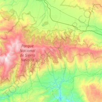
Name: Sierra Nevada topographic map, elevation, terrain.
Location: Sierra Nevada, Comarca de Guadix, Granada, Andalusia, Spain (36.96485 -3.47465 37.11652 -2.75624)
Average elevation: 1,310 m
Minimum elevation: 0 m
Maximum elevation: 3,439 m
Make a donation
Other topographic maps
Click on a map to view its topography, its elevation and its terrain.
Gor
Spain > Andalusia > Comarca de Guadix
Gor is a town of Granada, in southwestern Spain. It consists of the town center and several suburbs scattered all over its municipal area, such as Las Juntas, Las Viñas, Cenascuras, Los Balcones, La Rambla Valdiquín, Los corrales, El Royo Serval and La Estación de Gorafe. Situated at an altitude of between…
Average elevation: 1,351 m
Make a donation
Puero de Jeres
Spain > Andalusia > Comarca de Guadix > Jérez del Marquesado
Average elevation: 2,671 m
Guadix
Spain > Andalusia > Comarca de Guadix
The city lies at an altitude of 913 metres, in the centre of the Hoya of Guadix, a high plain at the northern foothills of the Sierra Nevada. It is located on the Linares Baeza–Almería railway. The city was built in the vicinity of gullies and badlands.
Average elevation: 1,043 m
Make a donation