
Thank you for supporting this site ❤️
Make a donation
Make a donation
IHDP Colony(2) topographic map
Click on the map to display elevation.
Thank you for supporting this site ❤️
Make a donation
Make a donation
About this map
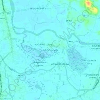
Name: IHDP Colony(2) topographic map, elevation, terrain.
Location: IHDP Colony(2), Vaikom, Kottayam, Kerala, 686608, India (9.77200 76.39526 9.81200 76.43526)
Average elevation: 4 m
Minimum elevation: -1 m
Maximum elevation: 36 m
Thank you for supporting this site ❤️
Make a donation
Make a donation
Other topographic maps
Click on a map to view its topography, its elevation and its terrain.
Thank you for supporting this site ❤️
Make a donation
Make a donation
Arakkulam
India > Kerala > Vaikom > Thalayolaparambu > Chundangakari vadachira colony
Average elevation: 6 m