
Thank you for supporting this site ❤️
Make a donation
Make a donation
Barton Creek topographic map
Click on the map to display elevation.
Thank you for supporting this site ❤️
Make a donation
Make a donation
About this map
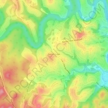
Name: Barton Creek topographic map, elevation, terrain.
Location: Barton Creek, Travis County, Texas, 78735, United States (30.26430 -97.89541 30.30430 -97.85541)
Average elevation: 247 m
Minimum elevation: 189 m
Maximum elevation: 306 m
Thank you for supporting this site ❤️
Make a donation
Make a donation
Other topographic maps
Click on a map to view its topography, its elevation and its terrain.
Thank you for supporting this site ❤️
Make a donation
Make a donation
Thank you for supporting this site ❤️
Make a donation
Make a donation
Thank you for supporting this site ❤️
Make a donation
Make a donation
Mary Moore Searight zMetropolitan Park
United States > Texas > Travis County > Austin
Average elevation: 201 m
Thank you for supporting this site ❤️
Make a donation
Make a donation
Walnut Creek Metropolitan Park
United States > Texas > Travis County > Austin
Average elevation: 214 m
Thank you for supporting this site ❤️
Make a donation
Make a donation
Thank you for supporting this site ❤️
Make a donation
Make a donation