
Thank you for supporting this site ❤️
Make a donation
Make a donation
Wernshausen topographic map
Click on the map to display elevation.
Thank you for supporting this site ❤️
Make a donation
Make a donation
About this map
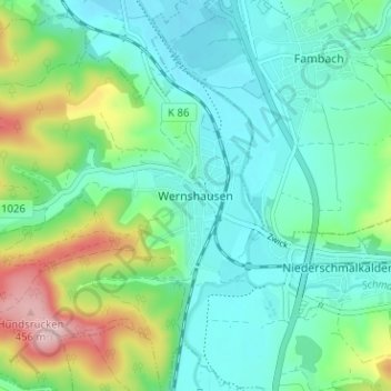
Name: Wernshausen topographic map, elevation, terrain.
Average elevation: 304 m
Minimum elevation: 245 m
Maximum elevation: 472 m
Thank you for supporting this site ❤️
Make a donation
Make a donation
Other topographic maps
Click on a map to view its topography, its elevation and its terrain.
Volkers
Deutschland > Thüringen > Landkreis Schmalkalden-Meiningen > Schmalkalden
Average elevation: 426 m