
Thank you for supporting this site ❤️
Make a donation
Make a donation
Elsene topographic map
Click on the map to display elevation.
Thank you for supporting this site ❤️
Make a donation
Make a donation
About this map
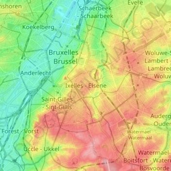
Name: Elsene topographic map, elevation, terrain.
Location: Elsene, Brussel-Hoofdstad, Brussel Hoofdstad, 1050, België (50.79311 4.32683 50.87311 4.40683)
Average elevation: 62 m
Minimum elevation: 12 m
Maximum elevation: 121 m
Thank you for supporting this site ❤️
Make a donation
Make a donation
Other topographic maps
Click on a map to view its topography, its elevation and its terrain.