
Thank you for supporting this site ❤️
Make a donation
Make a donation
Catherine topographic map
Click on the map to display elevation.
Thank you for supporting this site ❤️
Make a donation
Make a donation
About this map
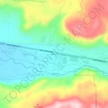
Name: Catherine topographic map, elevation, terrain.
Location: Catherine, Garfield County, Colorado, United States (39.38721 -107.17283 39.42721 -107.13283)
Average elevation: 2,020 m
Minimum elevation: 1,891 m
Maximum elevation: 2,229 m
Thank you for supporting this site ❤️
Make a donation
Make a donation
Other topographic maps
Click on a map to view its topography, its elevation and its terrain.
Glenwood Springs
United States > Colorado > Garfield County
Local food production has seen a revival in recent years. While not as consistently fecund as the extensive agricultural and viticultural areas at lower altitude such as Palisade, most types of fruit and vegetable grow well in the light and soil if well watered. Stonefruit such as cherries, peaches, and plums,…
Average elevation: 2,081 m
Thank you for supporting this site ❤️
Make a donation
Make a donation
Thank you for supporting this site ❤️
Make a donation
Make a donation