
Thank you for supporting this site ❤️
Make a donation
Make a donation
Heath and Reach topographic map
Click on the map to display elevation.
Thank you for supporting this site ❤️
Make a donation
Make a donation
About this map
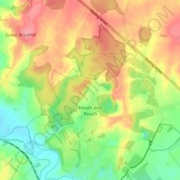
Name: Heath and Reach topographic map, elevation, terrain.
Location: Heath and Reach, Central Bedfordshire, England, United Kingdom (51.93401 -0.68300 51.96828 -0.60979)
Average elevation: 120 m
Minimum elevation: 75 m
Maximum elevation: 165 m
Thank you for supporting this site ❤️
Make a donation
Make a donation
Other topographic maps
Click on a map to view its topography, its elevation and its terrain.
Little Billington
United Kingdom > England > Central Bedfordshire > Great Billington > Little Billington
Average elevation: 92 m
Thank you for supporting this site ❤️
Make a donation
Make a donation