
Thank you for supporting this site ❤️
Make a donation
Make a donation
Humphrey topographic map
Click on the map to display elevation.
Thank you for supporting this site ❤️
Make a donation
Make a donation
About this map
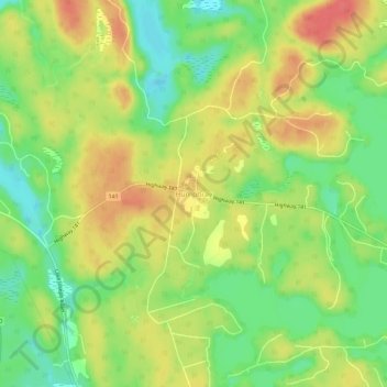
Name: Humphrey topographic map, elevation, terrain.
Average elevation: 255 m
Minimum elevation: 225 m
Maximum elevation: 284 m
Thank you for supporting this site ❤️
Make a donation
Make a donation
Other topographic maps
Click on a map to view its topography, its elevation and its terrain.
Diamond Lake
Canada > Ontario > Parry Sound District > Seguin Township > Orrville
Average elevation: 273 m
Thank you for supporting this site ❤️
Make a donation
Make a donation
Oastler Lake Provincial Park
Canada > Ontario > Parry Sound District > Seguin Township
Average elevation: 218 m