
Walde topographic map
Interactive map
Click on the map to display elevation.
About this map
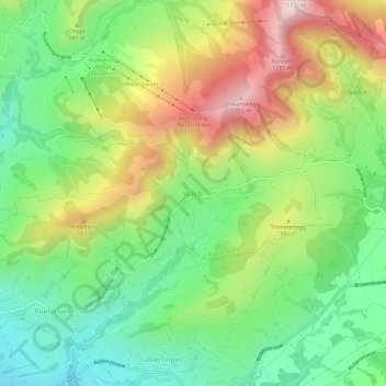
Name: Walde topographic map, elevation, terrain.
Average elevation: 896 m
Minimum elevation: 624 m
Maximum elevation: 1,310 m
Other topographic maps
Click on a map to view its topography, its elevation and its terrain.
Höchhand
Schweiz > Sankt Gallen > Wahlkreis See-Gaster > Eschenbach (SG)
Höchhand, Eschenbach (SG), Wahlkreis See-Gaster, Sankt Gallen, 8733, Schweiz
Average elevation: 1,016 m