
Thank you for supporting this site ❤️
Make a donation
Make a donation
Blue Mountains topographic map
Click on the map to display elevation.
Thank you for supporting this site ❤️
Make a donation
Make a donation
About this map
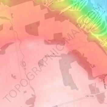
Name: Blue Mountains topographic map, elevation, terrain.
Average elevation: 456 m
Minimum elevation: 230 m
Maximum elevation: 511 m
Thank you for supporting this site ❤️
Make a donation
Make a donation
Other topographic maps
Click on a map to view its topography, its elevation and its terrain.
Pretty River Valley Provincial Park
Canada > Ontario > Grey County > The Blue Mountains
Average elevation: 418 m
Craigleith Provincial Park
Canada > Ontario > Grey County > The Blue Mountains
Average elevation: 215 m