
Torres del Paine topographic map
Interactive map
Click on the map to display elevation.
About this map
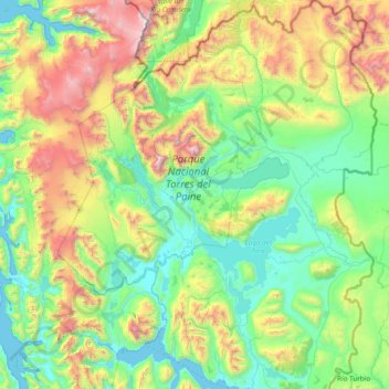
Name: Torres del Paine topographic map, elevation, terrain.
Average elevation: 629 m
Minimum elevation: -2 m
Maximum elevation: 2,745 m
Other topographic maps
Click on a map to view its topography, its elevation and its terrain.
Stubbenkammer
Chile > Region von Magellan und der chilenischen Antarktis > Provincia de Última Esperanza > Natales
Stubbenkammer, Natales, Provincia de Última Esperanza, Region von Magellan und der chilenischen Antarktis, Chile
Average elevation: 75 m
Lazo
Chile > Region von Magellan und der chilenischen Antarktis > Provincia de Última Esperanza > Torres del Paine > Lazo
Lazo, Torres del Paine, Provincia de Última Esperanza, Region von Magellan und der chilenischen Antarktis, Chile
Average elevation: 442 m