
Thank you for supporting this site ❤️
Make a donation
Make a donation
Lenox topographic map
Click on the map to display elevation.
Thank you for supporting this site ❤️
Make a donation
Make a donation
About this map
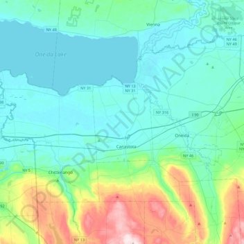
Name: Lenox topographic map, elevation, terrain.
Location: Lenox, Madison County, New York, 13032, United States (42.95128 -75.91818 43.27128 -75.59818)
Average elevation: 195 m
Minimum elevation: 110 m
Maximum elevation: 564 m
Thank you for supporting this site ❤️
Make a donation
Make a donation
Other topographic maps
Click on a map to view its topography, its elevation and its terrain.
Village of Hamilton
United States > New York > Madison County
Northeast of Hamilton is Payne Brook, which starts at Lake Moraine and travels through the village before converging with the Chenango River. The elevation of the village's municipal airport (Hamilton Municipal Airport) is approximately 1,100 feet (340 m) above sea level.
Average elevation: 386 m
Thank you for supporting this site ❤️
Make a donation
Make a donation
Thank you for supporting this site ❤️
Make a donation
Make a donation