
Thank you for supporting this site ❤️
Make a donation
Make a donation
Mount Potts topographic map
Click on the map to display elevation.
Thank you for supporting this site ❤️
Make a donation
Make a donation
About this map
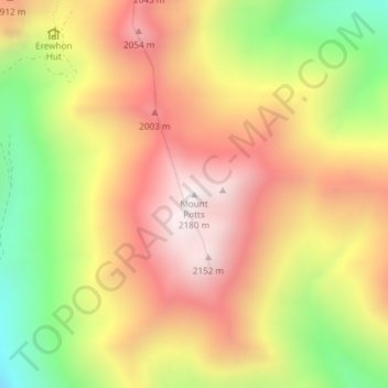
Name: Mount Potts topographic map, elevation, terrain.
Location: Mount Potts, Ashburton District, New Zealand (-43.50263 170.92481 -43.50253 170.92491)
Average elevation: 1,734 m
Minimum elevation: 1,180 m
Maximum elevation: 2,177 m
Thank you for supporting this site ❤️
Make a donation
Make a donation
Other topographic maps
Click on a map to view its topography, its elevation and its terrain.