
La Melgosa topographic map
Interactive map
Click on the map to display elevation.
About this map
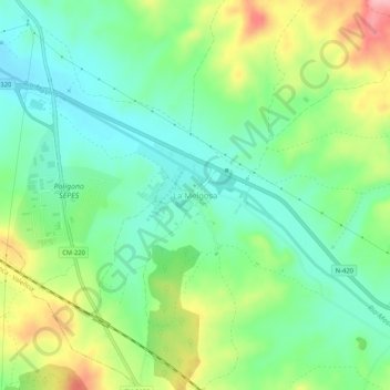
Name: La Melgosa topographic map, elevation, terrain.
Location: La Melgosa, Cuenca, Castilla-La Mancha, 16193, España (40.00604 -2.11551 40.04604 -2.07551)
Average elevation: 972 m
Minimum elevation: 922 m
Maximum elevation: 1,068 m
Other topographic maps
Click on a map to view its topography, its elevation and its terrain.
Ciudad Encantada
España > Castilla-La Mancha > Cuenca
Ciudad Encantada, Valdecabras, Cuenca, Castilla-La Mancha, 16152, España
Average elevation: 1,356 m
Fuente Carrasca
España > Castilla-La Mancha > Cuenca
Fuente Carrasca, Cuenca, Castilla-La Mancha, 16001, España
Average elevation: 1,143 m
Ocejón
España > Castilla-La Mancha > Cuenca
Ocejón, Cuenca, Castilla-La Mancha, España
Average elevation: 1,648 m