
Okrika topographic map
Interactive map
Click on the map to display elevation.
Okrika
The average elevation of Okrika is 452 metres. It lies on the north of the Bonny River and on Okrika Island, 35 miles (56 km) upstream from the Bight of Bonny. The town can be reached by vessels of a draft of 29 feet (9 metres) or less.
About this map
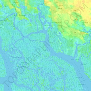
Name: Okrika topographic map, elevation, terrain.
Location: Okrika, Rivers, Nigeria (4.57788 6.98215 4.80582 7.20012)
Average elevation: 4 m
Minimum elevation: -6 m
Maximum elevation: 25 m
Other topographic maps
Click on a map to view its topography, its elevation and its terrain.