
Thank you for supporting this site ❤️
Make a donation
Make a donation
Formiguères topographic map
Click on the map to display elevation.
Thank you for supporting this site ❤️
Make a donation
Make a donation
About this map
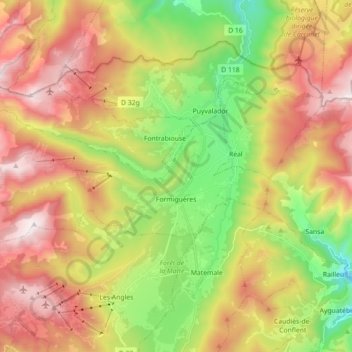
Name: Formiguères topographic map, elevation, terrain.
Average elevation: 1,787 m
Minimum elevation: 1,166 m
Maximum elevation: 2,472 m
Thank you for supporting this site ❤️
Make a donation
Make a donation
Other topographic maps
Click on a map to view its topography, its elevation and its terrain.
Saint-Cyprien Plage
Frankrijk > Occitanië > Pyrénées-Orientales > Saint-Cyprien
Average elevation: 1 m
Thank you for supporting this site ❤️
Make a donation
Make a donation
Les Vinyes de Saint-Marti
Frankrijk > Occitanië > Pyrénées-Orientales > Maureillas-las-Illas > Les Vinyes de Saint-Marti
Average elevation: 147 m