
Thank you for supporting this site ❤️
Make a donation
Make a donation
Jasper topographic map
Click on the map to display elevation.
Thank you for supporting this site ❤️
Make a donation
Make a donation
About this map
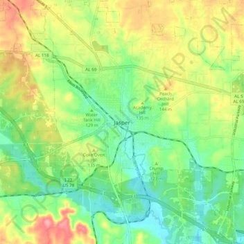
Name: Jasper topographic map, elevation, terrain.
Location: Jasper, Walker County, Alabama, 35501, United States (33.79122 -87.31751 33.87122 -87.23751)
Average elevation: 123 m
Minimum elevation: 81 m
Maximum elevation: 186 m
Thank you for supporting this site ❤️
Make a donation
Make a donation
Other topographic maps
Click on a map to view its topography, its elevation and its terrain.
Tanyard Creek
United States > Alabama > Walker County > Jasper > Frisco Quarters
Average elevation: 110 m