
Thank you for supporting this site ❤️
Make a donation
Make a donation
Incline Village topographic map
Click on the map to display elevation.
Thank you for supporting this site ❤️
Make a donation
Make a donation
About this map
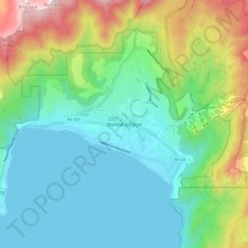
Name: Incline Village topographic map, elevation, terrain.
Average elevation: 2,175 m
Minimum elevation: 1,895 m
Maximum elevation: 2,923 m
Thank you for supporting this site ❤️
Make a donation
Make a donation
Other topographic maps
Click on a map to view its topography, its elevation and its terrain.
Thank you for supporting this site ❤️
Make a donation
Make a donation
Sand Harbor
United States > Nevada > Washoe County > Incline Village-Crystal Bay
Average elevation: 2,006 m
Thank you for supporting this site ❤️
Make a donation
Make a donation