
Make a donation
Cañon City topographic map
Click on the map to display elevation.
Make a donation
Cañon City
Cañon City is located in eastern Fremont County at 38°26′48″N 105°13′42″W / 38.44667°N 105.22833°W / 38.44667; -105.22833 (38.446800, -105.228305) at an altitude of 5,332 feet (1,625 m). It sits primarily on the north side of the Arkansas River, just east of where the river exits from Royal Gorge. It is bordered to the south by the unincorporated community of Lincoln Park. Via U.S. Route 50, Pueblo is 39 miles (63 km) to the east and Poncha Springs is 62 miles (100 km) to the west. Colorado Springs is 45 miles (72 km) to the northeast.
Make a donation
About this map
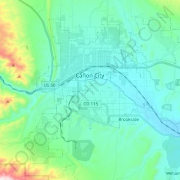
Name: Cañon City topographic map, elevation, terrain.
Location: Cañon City, Fremont County, Colorado, 81212, United States (38.38784 -105.27392 38.47835 -105.13228)
Average elevation: 1,723 m
Minimum elevation: 1,582 m
Maximum elevation: 2,404 m
Make a donation
Other topographic maps
Click on a map to view its topography, its elevation and its terrain.
Make a donation
Make a donation