
Masbate topographic map
Interactive map
Click on the map to display elevation.
About this map
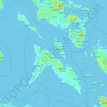
Name: Masbate topographic map, elevation, terrain.
Location: Masbate, Bicol Region, Philippines (11.51538 122.69779 13.35834 124.19422)
Average elevation: 28 m
Minimum elevation: -2 m
Maximum elevation: 2,293 m
The general surface configuration of the province ranges from slightly undulating to rolling and from hilly to mountainous. In each island, the rugged topography is concentrated in the northeastern portion and gradually recedes to blunt hills and rolling areas in the south, southeast, and southwest.
Other topographic maps
Click on a map to view its topography, its elevation and its terrain.